Key Takeaways
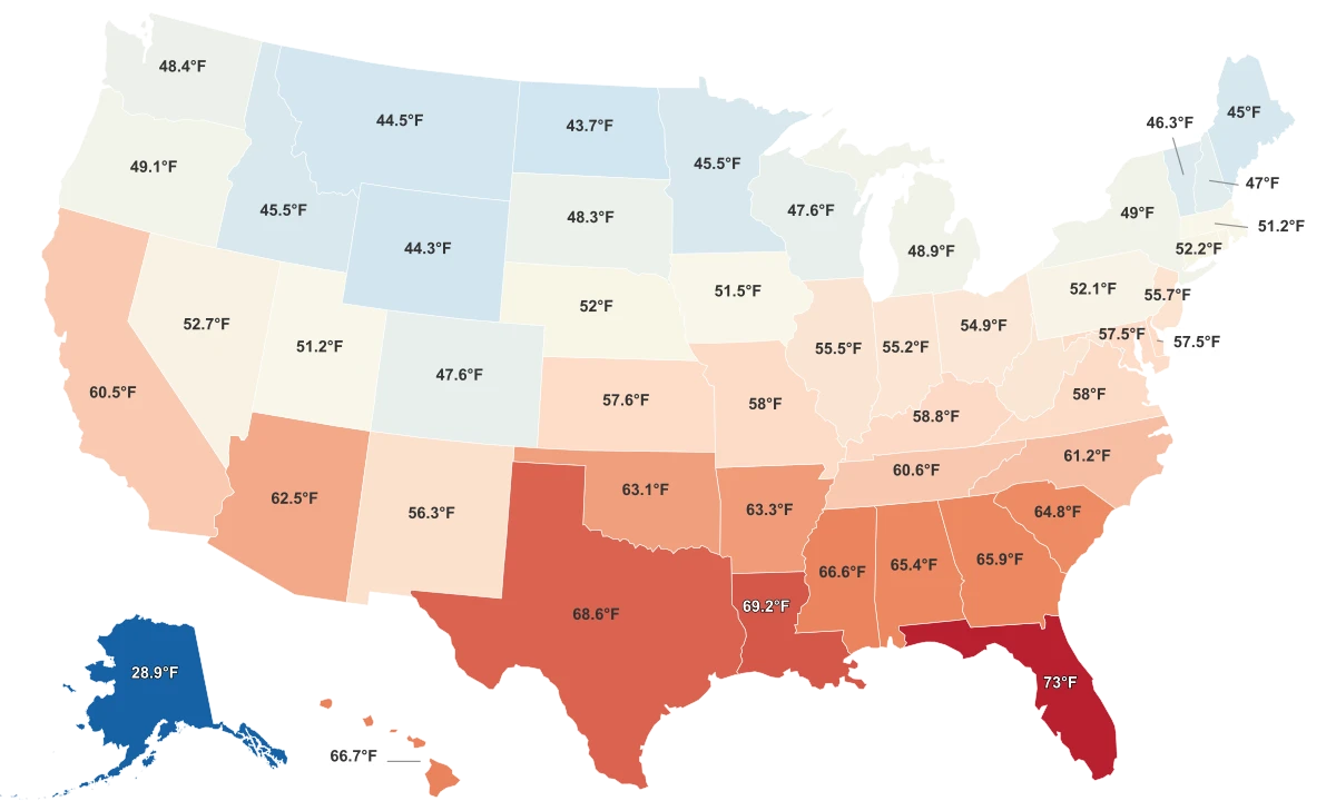
- Alaska is the coldest state, averaging just 28.9°F in 2024, the lowest in the country.
- Florida is the warmest, at 73.0°F, the only state that tops 70 degrees.
- The gap between Alaska and the next-coldest state, North Dakota at 43.7°F, is 14.8°F.
- How deep the ground freezes alone explains roughly four-fifths of why one state is colder than another.
Alaska Is in a Climate of Its Own
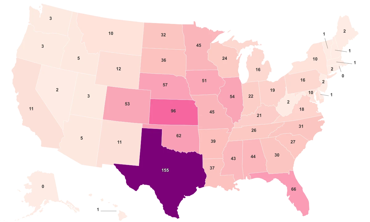
The coldest state in the country is Alaska, which averaged just 28.9°F across 2024, while the warmest, Florida, averaged 73.0°F. These figures come from NOAA's National Centers for Environmental Information, the federal record for U.S. temperature, and reflect each state's average annual temperature for the 2024 calendar year. Because this is a ranking of the coldest states, lower numbers rank first: the colder a state, the higher it sits on the list.
A statewide average is not one thermometer's reading. NOAA builds it from thousands of station observations, spread across a fine grid and weighted by area, so the number describes a whole state at once. One caution: these are 2024 figures, a single year rather than a long-run climate normal, which NOAA measures over 30-year intervals, so they capture one year's weather, not a permanent baseline.
What makes Alaska remarkable is not just that it leads, but by how much. The next-coldest state, North Dakota, averaged 43.7°F. That leaves Alaska 14.8°F colder than any other state in the union, a margin wider than the distance separating North Dakota from states in the mid-50s. Alaska does not sit at the cold end of the table so much as occupy a category by itself.
| Rank | State | Average Temperature (2024) |
|---|---|---|
| 1 | Alaska | 28.9°F |
| 2 | North Dakota | 43.7°F |
| 3 | Wyoming | 44.3°F |
| 4 | Montana | 44.5°F |
| 5 | Maine | 45.0°F |
| 50 | Florida | 73.0°F |
The Cold Map Is a North-and-Elevation Map
Set Alaska aside and a clear question follows: is the rest of the cold scattered at random, or does it have an address? It has an address. Outside Alaska, most states bunch tightly in the mid-50s, so the ranking is less a gradual slope than one extreme against a crowded middle. The real divide is regional: the Northeast is the coldest census region in the country, averaging close to 50°F, while the South sits near 63°F, a roughly 13-degree gap that forms the spine of the whole map.
That gap starts with latitude. NOAA notes that the sun's energy is concentrated near the equator while far less reaches the poles, causing the tropics to warm and the poles to cool. Much of Alaska lies at or above the Arctic Circle, near 66 degrees north, where long sunless stretches and the high reflectivity of snow and ice leave the ground starved of heat.
But latitude is not the only lever. Several Mountain-West states ranked cold while sitting well south of Maine. Wyoming averaged 44.3°F and Montana 44.5°F, colder than far-northern states, because altitude can stand in for latitude. NOAA's methodology accounts directly for the effect of elevation, which is why a high state in the interior West can match the chill of one near the Canadian border.
What Cold Does to the Ground and the Calendar
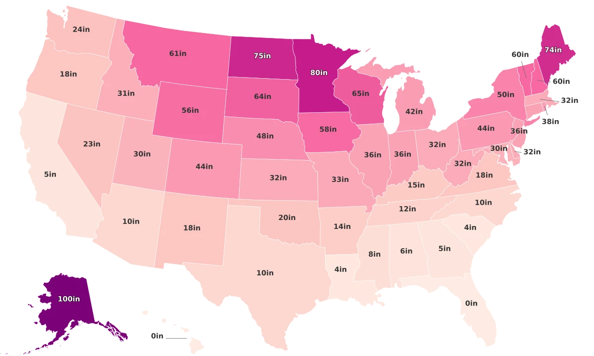
Cold is not just a number on a map. It reaches into the ground and onto the calendar, and the data shows how tightly those consequences follow the thermometer. The clearest is the frost line, the depth winter cold drives into the soil. Across all 50 states, how deep the ground freezes moves almost perfectly opposite to temperature, and it alone explains roughly four-fifths of why one state is colder than another.
The extremes make the point in plain units. In Alaska, frost reaches down on the order of 100 inches, deep enough to shape how foundations and pipes are built. In Florida, the ground effectively never freezes at all. The colder the air, the deeper the cold travels underground, with little daylight between the two.
Cold Decides How Deep the Ground Freezes
Across all 50 states, lower average temperatures push the winter frost line far deeper into the soil.
The calendar tells the same story. The number of days a state spends under snow tracks nearly as closely with temperature, explaining a little under three-quarters of the difference between states. Alaska averages around 145 snow-covered days a year, more than any other state, so its cold is not only the deepest but also the longest. Where the average temperature falls, the frost follows it down and the snow stays longer.