Frost Lines By State

United StatesUnited States
33.42 inFrost LineNational Average
54.73 °FAverage TemperatureNational Average
26.96 inAnnual SnowfallNational Average
Frost LineQuestion Mark
Map visualization
0 in100 in
1
AlaskaAlaska
100in
2
MinnesotaMinnesota
80in
3
North DakotaNorth Dakota
75in
4
MaineMaine
74in
5
WisconsinWisconsin
65in
6
South DakotaSouth Dakota
64in
7
MontanaMontana
61in
8
VermontVermont
60in
8
New HampshireNew Hampshire
60in
10
IowaIowa
58in
11
WyomingWyoming
56in
12
New YorkNew York
50in
13
NebraskaNebraska
48in
14
PennsylvaniaPennsylvania
44in
14
ColoradoColorado
44in
16
MichiganMichigan
42in
17
Rhode IslandRhode Island
38in
18
New JerseyNew Jersey
36in
18
IndianaIndiana
36in
18
ConnecticutConnecticut
36in
18
IllinoisIllinois
36in
22
MissouriMissouri
33in
23
DelawareDelaware
32in
23
KansasKansas
32in
23
MassachusettsMassachusetts
32in
23
OhioOhio
32in
23
West VirginiaWest Virginia
32in
28
IdahoIdaho
31in
29
UtahUtah
30in
29
MarylandMaryland
30in
31
WashingtonWashington
24in
32
NevadaNevada
23in
33
OklahomaOklahoma
20in
34
VirginiaVirginia
18in
34
OregonOregon
18in
34
New MexicoNew Mexico
18in
37
KentuckyKentucky
15in
38
ArkansasArkansas
14in
39
TennesseeTennessee
12in
40
TexasTexas
10in
40
North CarolinaNorth Carolina
10in
40
ArizonaArizona
10in
43
MississippiMississippi
8in
44
AlabamaAlabama
6in
45
GeorgiaGeorgia
5in
45
CaliforniaCalifornia
5in
47
South CarolinaSouth Carolina
4in
47
LouisianaLouisiana
4in
49
HawaiiHawaii
0in
49
FloridaFlorida
0in
Share

Last updated February 28, 2026

Frost Lines Across America

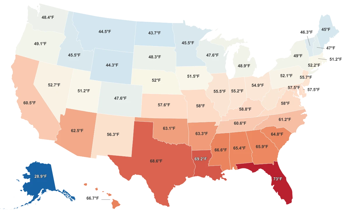
Understanding the depth of the frost line, the level below the earth's surface at which point groundwater freezes, is crucial for a range of applications, from city planning and building construction to understanding and managing our climate. Across different states in the U.S., the frost line depth varies drastically, primarily influenced by the geographical location and overall climate of a region. The states situated closer to the poles generally have deeper frost lines due to more intense and prolonged cold temperatures, while those located towards the equator tend to have shallower frost lines.

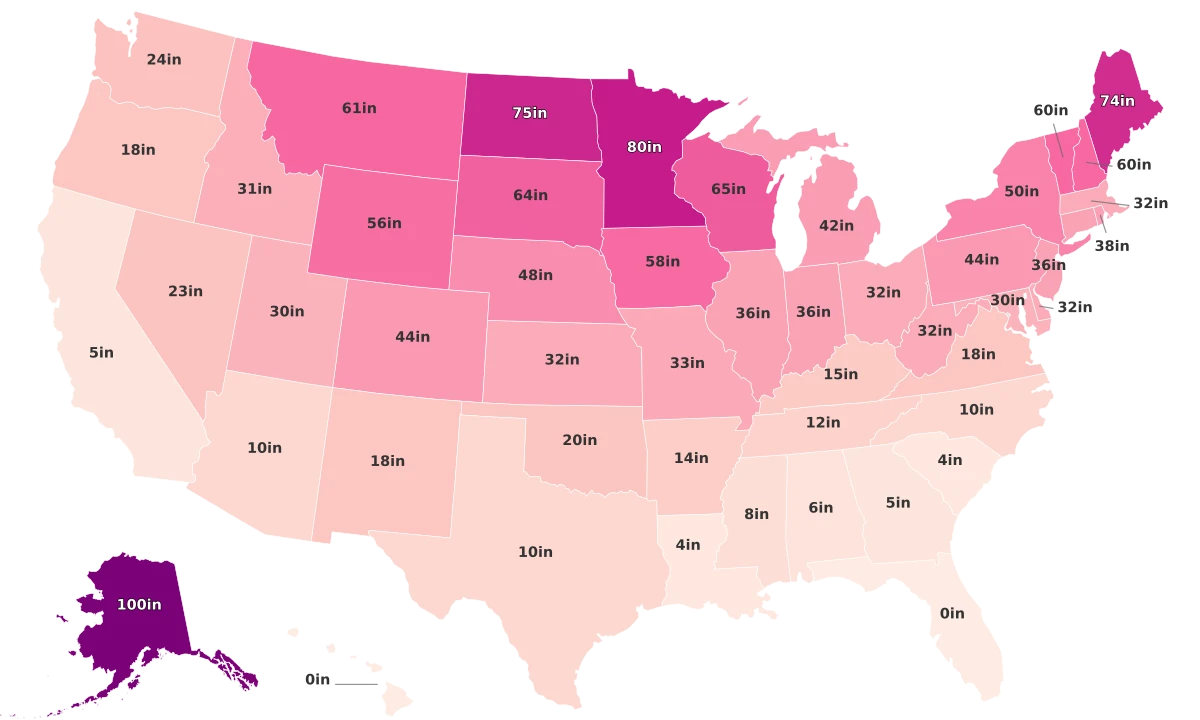
  • The frost line depth ranges widely across states - from as deep as 100 inches in Alaska to virtually non-existent in Hawaii and Florida.
  • The coldest states, including Alaska, Minnesota, and North Dakota, have the deepest frost lines amongst all states. For instance, Alaska leads with an impressive 100-inch frost line depth, followed by Minnesota at 80 inches and North Dakota at 75 inches.
  • Conversely, states with traditionally warmer climates tend to have shallower frost lines. This is seen in Florida and Hawaii, where the frost line depth is zero inches - an attribute of their tropical climate. Similarly, Louisiana and South Carolina have minimal frost lines at four inches, while California and Georgia measure at only five inches.
  • Among the top ten states with the deepest frost lines, nine of them are located in the northern part of the country. This follows the general understanding that frost lines are deeper in regions closer to the poles.
  • On the contrary, states ranked at the bottom, extending from Florida to Mississippi, are predominantly situated in the southern region, which corresponds to their warmer climate and thus, shallower frost lines.

All Metrics

Sources & Notes

Average Temperature

Average annual temperature.

Keep reading

Additional Rankings

GDP By State
Economy
States

GDP By State

Gambling Age by State
Legality
States

Gambling Age by State

Gas Price By State
Prices
States

Gas Price By State

Gay Population By State

Gay Population By State

Gayest Cities in America

Gayest Cities in America

Gini Coefficient By Country
Demographics
Countries

Gini Coefficient By Country