.png)
.svg)
States By Area
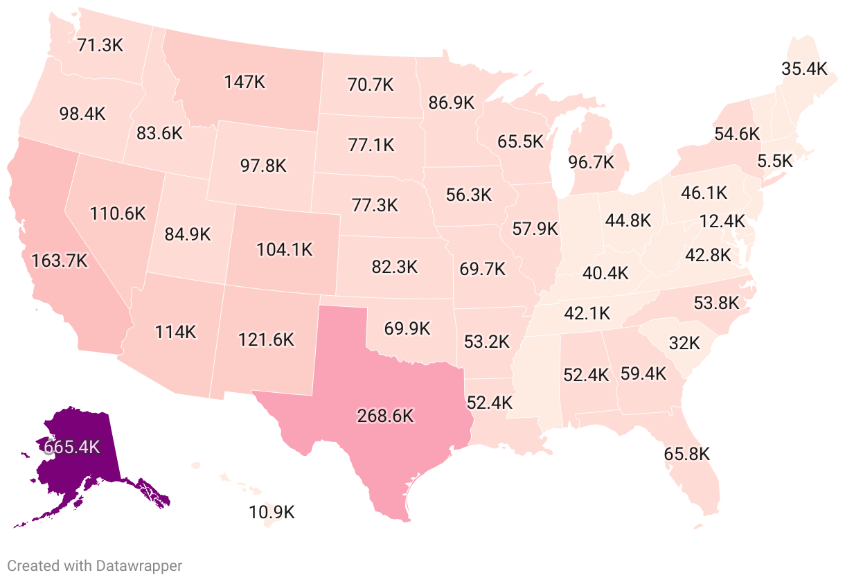

A Look at States by Area
The United States of America is a melting pot of cultures, landscapes, and sizes. Spanning different time zones and climates, the 50 states in this expansive nation vary dramatically in their geographies, offering immense, undisturbed wildernesses in some regions and densely populated urban landscapes in others. The area each state occupies plays a major role in its economy, lifestyle, and even its identity.
Key Findings:
- Size Knows No Boundaries: Alaska, geographically, stands unparalleled. Its total area of 665,384 square miles makes it the behemoth of the states, dwarfing all others. It is over twice the size of Texas, the second-largest state, which itself is a considerable size of 268,596 square miles.
- All Sizes Matter: While states like Alaska, Texas, and California dominate the list with their massive land areas, the United States is also home to states at the other end of the spectrum. States like Rhode Island, Delaware, and Connecticut, with areas of 1,545, 2,489, and 5,543 square miles respectively, may be small in size, but they are nevertheless rich in cultural significance and historical value.
- Geographical Clustering: Interestingly, the western part of the United States boasts a larger proportion of the most sizeable states. Seven of the top 10 largest states, including Alaska, California, Montana, and Nevada, are located in the West. This pattern suggests a vast expanse of relatively undisturbed land in this part of the country, highlighting the geographical diversity across the United States.
- Profile of the Medium: The middle of the list presents a fascinating mix - states like Minnesota, Michigan, Utah, and Kansas have areas ranging from 82,278 to 96,714 square miles and offer a mix of landscapes, from the Great Lakes to the Rocky Mountains, showcasing the country's geographical variety.
Largest States by Area
By State
Full Data Set
Frequently Asked Questions
Methodology
Need Help?:
Need the full dataset or have any questions? Our team is happy to help. Contact us at: [email protected]
Need the full dataset or have any questions? Our team is happy to help. Contact us at: [email protected]